"Whenever I find myself growing grim about the mouth," writes Ishmael in Herman Melville classic novel Moby Dick, "I take myself to sea."
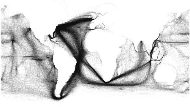
Ishmael was not the only one. For hundreds of years, ships have cut the ocean's salty waves, ferrying Ishmaels by the million between coasts and continents. As this striking data viz shows, their wanderings, when traced, result in an astonishingly accurate map of the world.
The visualization was created by Ben Schmidt, an assistant professor of history at Boston's Northeastern University. Schmidt, who is expert in using visualization techniques to explore the history of the 19th century, took data on over 200 years worth of ocean journeys available through the National Oceanic and Atmospheric Administration (NOAA), traced them out, and combined them into a single image.
Once all of these aquatic highways and byways have been traced out, the resulting visualization is astonishing. It's like watching some savant with an Etch-A-Sketch create a hyper-detailed map of the world just by tracing millions of lines back and forth.
In negative, Schmidt's visualization of 200 years of ocean voyaging results in an extremely accurate map of the world, where the continents are big blanks surrounded by oceans filled in with filaments. And depending on the relative thickness and darkness of these hair-like strands, you can tell which routes were the major shipping ones, and which were just the random one-off voyages of eccentric yachters or lone adventurers.
The data itself comes from a variety of original sources. Starting in 1800, whaling vessels like Ishmael's Pequod, charted the oceans in pursuit of ivory, oil, and ambergris. Data becomes more detailed in the late 19th century and early 20th century, and the NOAA's climatological records from the period also encompass records of the movement of the U.S. Navy in World War II, the Japanese merchant marine over much of the post-Meiji period, and millions of other records showing the commercial and military interconnections at sea.

It has been said that given enough information, any system, no matter how complicated, can be recreated. Perhaps that is why I find Professor Schmidt's visualization so haunting. Each of these lines is the wandering of some sailor, whaler, or soldier. Each represents a separate adventure, the precise details of which have been lost to time, yet combined, they conjure from nothing a perfect simulacrum of the world they lived in.
As Mr. Melvilleaptly wrote, "Consider the subtleness of the sea." Subtle indeed. You can see it in these ghostly lines.